Guest 700- Registered: 11 Jun 2010
- Posts: 2,868
16 September 2010
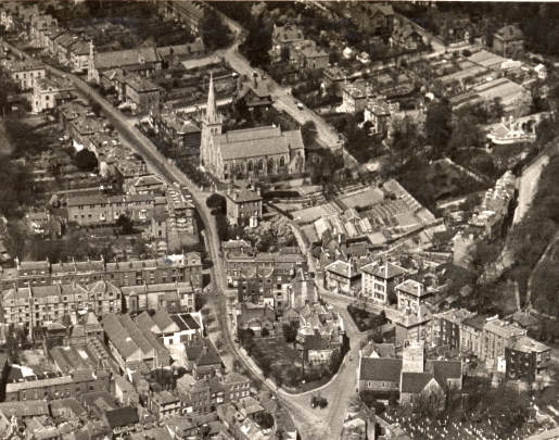
09:2871079Here is an interesting aerial photo (about 1929?) of Maison Dieu Road which goes up to the top left corner of the photo.
At the bottom right corner is old St James Church and churchyard, and White Horse.
Towards the top centre is 'new' St James Church. And further up St Peter and St Paul RC church.
At the three-way junction in front of old St James Church I think that is the pissoir centre of the road.
Is that a nursery slightly to right and below new St James Church ?
---------------------------------------------------
Lincolnshire Born and Bred
16 September 2010
09:5371088Hi Kath
Super picture
Not sure about the nursery site that you mention but top right hand of picture (Top of Taswell Street) is a nursery. My house was built in the 1960,s and is on this site.
I am often told by people who attended Castlmount School that they used to buy their apples etc from a stall which was located approx where my drive goes onto Taswell Street. This area of nursery is in fact now my house also next door house and all of Taswell Close.
We have the Dover Society plaque on our wall for the first aeriel bomb dropped on UK on 24th December 1914.
Although no plaque I am told that the first shell fired from France on Dover in WW11 in fact hit the road in Maison Dieu Road (told it was in front of number 105). I understand there were pictures taken at the time so maybe you have this in your collection.
Guest 655- Registered: 13 Mar 2008
- Posts: 10,247
16 September 2010
10:0071089Brilliant photo
16 September 2010
10:1771091Great photo. It really brings home what a thrashing Dover received in WW2. It is really hard to trace those roads in the present layout.
Guest 651- Registered: 12 Mar 2008
- Posts: 5,673
16 September 2010
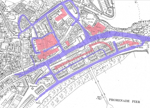
13:5871116Yes Kath - 1907 map shows a load of greenhouses, and 1939 Pikes says Ashen Tree Nursery
Diana - did this for a walk a fwe years ago, not sure how this will come out on here....
Been nice knowing you :)
Guest 651- Registered: 12 Mar 2008
- Posts: 5,673
16 September 2010
14:0071117We used this to show most of the current roads in purple and MFI/Gateway Flats/Burlington/Pool/carpark on top of the 1907 map
Been nice knowing you :)
Guest 700- Registered: 11 Jun 2010
- Posts: 2,868
16 September 2010
22:3671264Thanks Pat for this information.
Bob says there was Clarks nursery, and Fisher and Goodburn's, the latter may have taken over from Clarks.
Taswell Street must be the street shown (at right angles to Maison Dieu Rd), about half way between the RC church and 'new St James' in the picture.
Yes, Bob says he has a copy of photo showing the holes in the road from the first shell, dropped on Maison Dieu Road, will see if we can find this. Interesting you have the Dov Soc plaque on your wall.
So, according to what Paul aka Scotchie says, it seems there were probably two separate nurseries in that area.
Does anyone know where the 'Dover Corporation nursery' was situated? Have a photo of this but it doesn't say where it was.
---------------------------------------------------
Lincolnshire Born and Bred
Guest 649- Registered: 12 Mar 2008
- Posts: 14,118
16 September 2010
22:4171265Kath,it was in Connaught Park all the way up on the leftside of the first green.
Guest 700- Registered: 11 Jun 2010
- Posts: 2,868
16 September 2010
23:0471276Many thanks Vic for this information.
Bob thinks there was another one (probably later) at River, between the church and (Phipps?) mill.
---------------------------------------------------
Lincolnshire Born and Bred
17 September 2010
07:4171282kath you are correct re Taswell Street
The other road (very wide) to the right of MDR and running parallel to it is Harold Street
Guest 649- Registered: 12 Mar 2008
- Posts: 14,118
17 September 2010
13:4171317There was one in River and I am living on it now.
Guest 690- Registered: 10 Oct 2009
- Posts: 4,150
19 September 2010
07:1171548Another fine picture Kath, and I`m actually using this one as my screensaver at the moment. As the church is in the centre, I`d assume that was the idea of the picture, and with all the other building`s around as a bonus. I think even driving at only 30mph down those empty roads at that time would have caused a stir.
Tell them that I came, and no one answered.
Guest 700- Registered: 11 Jun 2010
- Posts: 2,868
20 September 2010
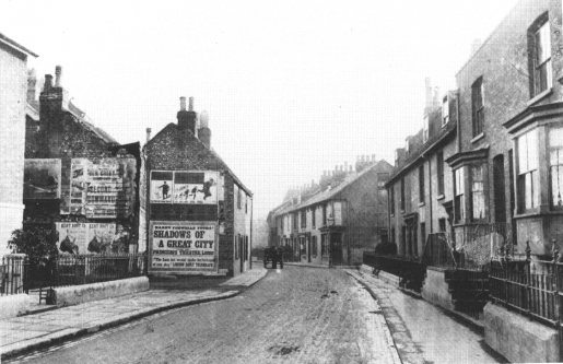
08:5571644Another aspect of Maison Dieu Road, c.1890s
---------------------------------------------------
Lincolnshire Born and Bred
Guest 700- Registered: 11 Jun 2010
- Posts: 2,868
30 September 2010
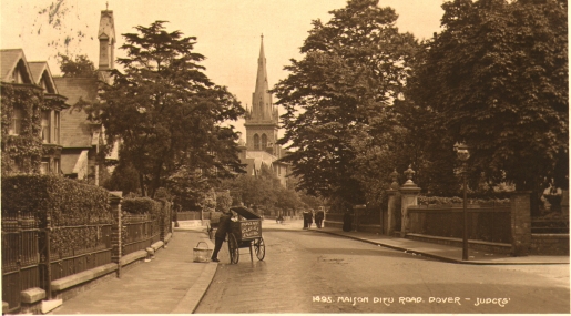
17:3973146And another aspect of Maison Dieu Road, showing 'new' St James Church which was demolished.
And showing a baker's van?
---------------------------------------------------
Lincolnshire Born and Bred
Terry Nunn
- Location: London Road, Dover
- Registered: 12 Mar 2008
- Posts: 4,316
30 September 2010
19:1373174That looks very much like the cart that my parents inherited when they took over the bakery. It was used to convey bread to the other shop at 87 London Road, now Stuff.
Terry
Quis custodiet ipsos custodes?
Guest 700- Registered: 11 Jun 2010
- Posts: 2,868
1 October 2010
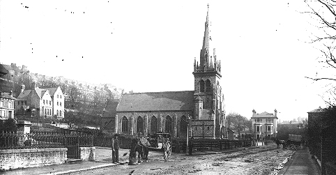
10:4773241Here is an earlier one, c.1900 showing the 'new' St James Church.
---------------------------------------------------
Lincolnshire Born and Bred
 ---------------------------------------------------
 Been nice knowing you :)
 ---------------------------------------------------
 ---------------------------------------------------
 ---------------------------------------------------